

Met Office issues new amber weather warning for parts of Northern Ireland
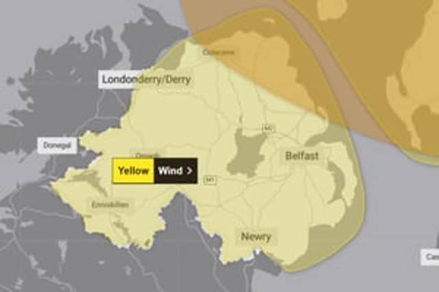

Met Office amber and yellow wind warnings will be in force for Northern Ireland this weekend.
The Met Office has issued a new amber wind warning for parts of Northern Ireland as Storm Boelo is predicted to hit this weekend.
The amber wind warning will be in force for Portrush, Coleraine, Ballycastle, Ballymoney and Larne from 9pm on Saturday 24 October to 9pm on Sunday 25 October.
The warning, which has a high (50-75%) likelihood and a significant impact, reads: “The strongest winds from Storm Boelo are expected from Saturday evening and extend eastwards through Sunday.
“Flying debris is likely and could lead to injuries or danger to life. There is a good chance that power cuts may occur, with the potential to affect other services, such as mobile phone coverage.
“Some damage to buildings and trees, such as tiles blown from roofs and large branches or trees blown over, is likely.
“Longer journey times and cancellations likely, as road, rail, air and ferry services may be affected. Some roads and bridges likely to close. Injuries and danger to life are likely from large waves and beach material being thrown onto coastal roads, sea fronts and properties.
“Very strong westerly winds associated with Storm Boelo are expected with fairly widespread gusts of 60 to 70 mph and gusts to 80 mph in exposed coastal areas.
“The strongest winds will initially affect western Scotland and far north of Northern Ireland on Saturday evening and then spread eastwards overnight and through Sunday.
“High winds will be accompanied by periods of heavy rain and frequent showers. Whilst high winds are expected across a wider area with a yellow warning in force, there is a higher confidence in impacts and disruption taking place within this amber warning area. The winds will gradually ease from the west through Sunday.”
Met office yellow wind warning for Northern Ireland
A Met Office yellow wind warning will also be in force for the whole of Northern Ireland from 10am on Sunday 24 October to 12am on Sunday 25 October.
The yellow wind warning, which has a low (10-25%) likelihood and a significant impact, reads: “Storm Boelo bringing a very windy spell this weekend with some disruption possible across parts of Northern Ireland.
“There is a chance that power cuts may occur, with the potential to affect other services, such as mobile phone coverage. There is a small chance of injuries and danger to life from flying debris. Some damage to buildings and trees, such as tiles blown from roofs and large branches or trees blown over, could happen.
“There is a small chance of longer journey times or cancellations as road, rail, air and ferry services are affected. There is a small chance that some roads and bridges could close.
“There is a small chance that injuries and danger to life could occur from large waves and beach material being thrown onto sea fronts, coastal roads and properties.
“Strong winds will spread across Northern Ireland during Saturday. Initially strong southerly winds will develop on Saturday morning, before stronger westerly winds follow later in the day.
“Very windy conditions will persist overnight and into Sunday before gradually easing from the south west during Sunday morning. Gusts of 50-60 mph are likely widely with some coastal and exposed areas potentially seeing gusts of 65-75 mph. Strong winds will be combined with blustery heavy showers.”